Maumee to Dillard’s Ferry is one of the easiest and most relaxing day floats on the Lower Buffalo River. It starts at South Maumee and ends at the Hwy 14 Bridge at Dillard’s Ferry, giving paddlers 9.3 miles of calm water, gentle shoals, and classic Buffalo River scenery. This is a great float for kids, beginners, or anyone who wants a laid-back day on the water. There are a few shoals along the way, but nothing I would call a rapid. If you want a peaceful Buffalo River float without committing to an overnight trip, this is a really good option.
The Lower Buffalo has a different feel than the more dramatic upper sections near Ponca and Jasper, but that is part of what makes it so enjoyable. It is less intense, usually less technical, and often floatable later into the season. So if you are looking for a low-stress Buffalo River float with plenty of places to stop, swim, and explore, Maumee to Dillard’s Ferry checks a lot of boxes.
Quick Glance
Distance: 9.3 miles
Difficulty: Easy
South Maumee Access: 36.039331, -92.635969
Spring Creek Access and Campground: 36.030562, -92.584407
Water Creek: 36.049759, -92.576566
Dillard’s Ferry / Hwy 14 Bridge: 36.066920, -92.578330
(Copy/Paste Coordinates into GPS or Google Maps search bar)
Directions
For Maumee to Dillard’s Ferry, I recommend using a shuttle if you can. This is not a terrible self-shuttle, but it still takes time. A paid shuttle lets you spend more of your day floating and less of it driving backroads between access points. Crockett’s Canoe Rental is a good option for shuttles and boat rentals in this area. They are located on Hwy 14 near the Buffalo River, which makes them convenient for this section of the Lower Buffalo.
If you are self-shuttling, drop your take-out vehicle at Dillard’s Ferry first. Dillard’s Ferry is located at the Hwy 14 Bridge over the Buffalo River, between Yellville and Harriet. The access is easy to find, and it is one of the better-known crossings on the Lower Buffalo. After dropping a vehicle there, head back toward South Maumee. From Marshall, drive north on Hwy 27 for about 5.4 miles. Then turn north on South Maumee Road, which is listed as County Road 52 on Google Maps. Follow it for about 6.8 miles until it dead-ends at the river access.
The road into South Maumee is not difficult under normal conditions, but it does feel a little remote. As always, conditions can change after heavy rain. So take your time, especially if you are pulling a trailer or hauling several boats. If you are renting or using a shuttle service, confirm your meeting place ahead of time because cell service can be unreliable once you get down into the river valley.
What to Expect
The Float
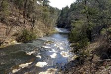
Floating Maumee to Dillard’s Ferry covers 9.3 miles of the Buffalo River. That makes it a comfortable day float for most paddlers. Depending on the water level and how often you stop, plan on spending about 5 to 7 hours on the river. This section is easy, with some shoals that add just enough movement to keep the float interesting. However, I would not classify any of them as rapids. Most of the time you can sit back, relax, and let the current do the work.
That is what makes this such a good beginner float. You still get the beauty of the Buffalo River, but without the stress of bigger whitewater. It is also a good choice for families with kids, as long as the river is at a safe level and everyone is wearing a PFD. Of course, easy does not mean careless. The Buffalo can still rise quickly after rain, and strainers or downed trees can create hazards anywhere. So check the water level before you go and keep an eye on the weather.
Scenery and Features
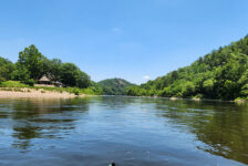
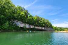
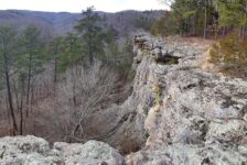
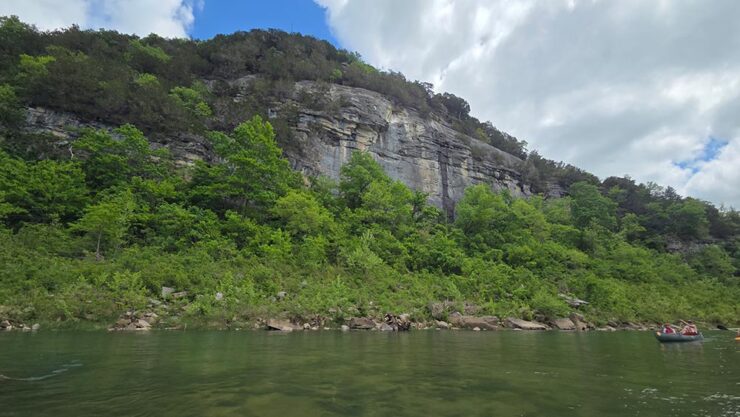
The Lower Buffalo has a different look than the upper river. The bluffs are still there, but they do not always rise straight up from the water like they do around Ponca, Kyle’s Landing, or Steel Creek. Some are set back from the river a bit, and trees partially hide the rock in places. Even so, this section still has plenty of scenery worth slowing down for. There are quiet bends, gravel bars, wooded hillsides, and enough bluff scenery to remind you that you are still on the Buffalo River.
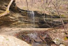
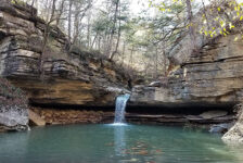
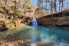
One of the best stops on this float is Water Creek. It flows into the Buffalo River on river-left, and it is easy to miss if you are not watching for it. A short hike up Water Creek leads to a hidden little oasis. After walking roughly 200 to 300 yards up the creek, you will find cool bluffs, rock formations, and a quieter side of the Buffalo that a lot of people probably float right past. It is a great place to pull off, stretch your legs, and explore for a bit. Just be careful walking up the creek. The rocks can be slick, and water levels can change how easy the walk is. Water shoes or sandals with good grip are helpful here.


Alternate Float Options
Spring Creek Access and Campground sits about halfway between South Maumee and Dillard’s Ferry. It is not really a major scenic highlight, but it is useful from a planning standpoint. If you want a shorter float, Spring Creek gives you another option. You could start at South Maumee and take out at Spring Creek. Or you could put in at Spring Creek and float down to Dillard’s Ferry, or Buffalo Point. Either option cuts this section into a shorter trip, which can be helpful if you are floating with younger kids or getting a late start.
If you want to make a longer trip out of this part of the Buffalo, you have options for that too. Upstream, the Grinders Ferry to South Maumee section is another great Lower Buffalo float. Downstream, you can continue past Dillard’s Ferry and turn this into part of the longer Maumee to Rush overnight float.
Plan Your Trip
Floating Time: 5-7 hours depending on flow and number of stops
Cell Service: Spotty to none in many areas
Dogs Allowed: Yes
Closest Outfitters: Crockett’s Canoe Rental
Maumee to Dillard’s Ferry is on the Lower Buffalo, which usually gives it a longer floating season than the upper sections. That does not mean it is always good to go, though. Before making the drive, check the river level on American Whitewater or the RiverApp. If the river is low, expect some dragging through the shoals. If it is too high, even an easy section can become dangerous. The Buffalo is a free-flowing river, so conditions can change fast after rain. When in doubt, call a local outfitter and ask what the river is doing that day.
Since this is a National River, take a little extra care while you are out there. Bring a trash bag, pack out everything you bring in, and do not take glass on the river. Also, please review the Buffalo National River Leave No Trace guidance before your trip. This is a beautiful stretch of river, and it only stays that way if people do their part.
If you want to spend the night or make a weekend out of it, there are campgrounds at South Maumee, Spring Creek, and Buffalo Point. But the best campground in the area, in my opinion, is Grassy Road Cabins and Camping. It is a great home base for floating the Lower Buffalo, and is featured in the YouTube video above. There are also plenty of Airbnb cabin options in the area if you want something a little more private or comfortable for the weekend.
For a relaxed day, start early enough that you do not have to rush. Water Creek is worth a stop, and there are usually plenty of gravel bars where you can swim, eat lunch, or just sit for a while. If you are bringing kids or beginners, Maumee to Dillard’s Ferry is a great section to introduce them to the Buffalo River. It is scenic, manageable, and forgiving at normal levels. Pack some snacks, watch the weather, and enjoy a slow day on one of the best rivers in Arkansas.