
#dryseasonhike

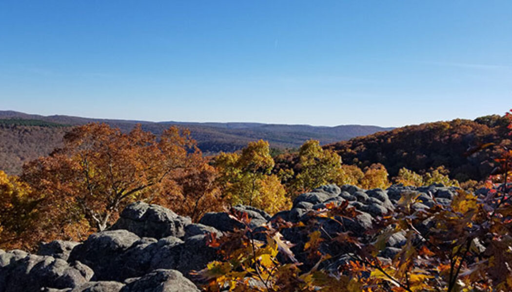
Hike to Devil’s Tea Table in the Lower Buffalo Wilderness
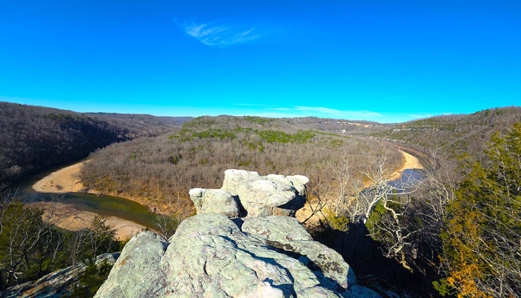
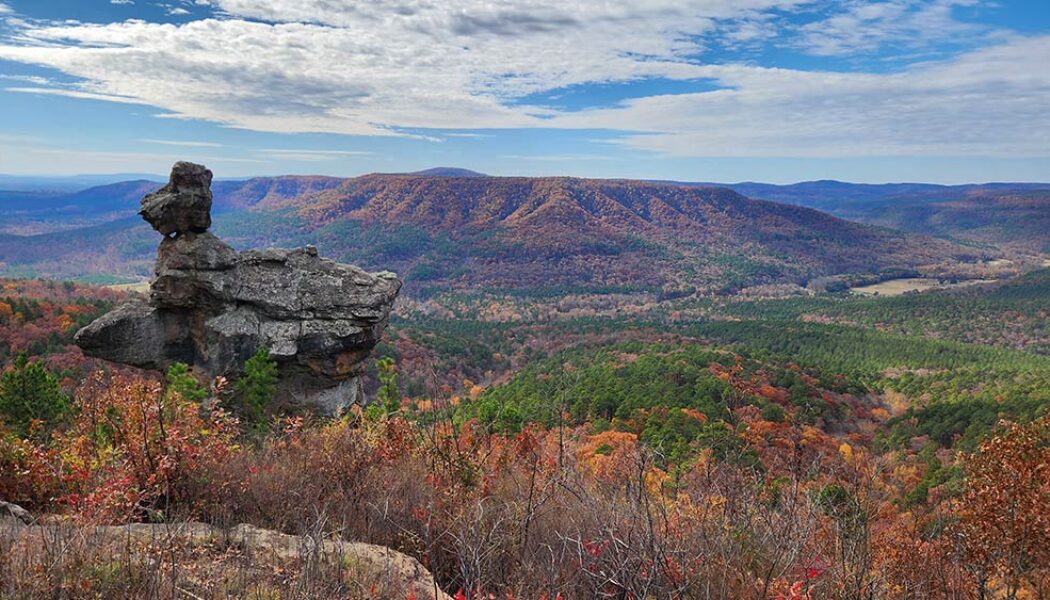
Hiking to Devil’s Tea Table is one of those Buffalo River experiences that quietly surprises you. The hike to Devil’s Tea Table leads to a massive rock formation perched above the Buffalo River in the Leatherwood Wilderness area of the Ozarks near the small community of Cozahome, Arkansas. From the edge, you get a wide, sweeping view of the river corridor below. Additionally, this area sits within a landscape packed with hiking opportunities along the Buffalo River and throughout the Leatherwood Wilderness. Sometimes we hike to waterfalls. But when there’s no rain, we find alternatives. During the dry season, we usually aim for views, caves, or unique rock features instead. The hike to Devil’s Tea Table delivers a huge rock formation sitting right on top of a scenic vista...

Hiking the Second Route to the Arkansas Sphinx
Some hikes are worth a re-visit. And a second viewing of that iconic monolith perched near the top of Hess Knob – known as the Arkansas Sphinx – is one such hike. There are two hiking routes you can take to the Sphinx. On my first trip there (read here), I opted for the shorter – but much steeper – route from parking area #1. While preparing for that hike, I read an article from the hiking blog of the late Rick Henry with info on a second route. Mr. Henry described the second route to the Arkansas Sphinx as longer, but less steep and strenuous than route #1. This route also hits the peak of Hess Knob with a magnificent vista view of the Sphinx and it’s scenic backdrop. So in my first Arkansas Sphinx article and video, I promised to come back to try the second ...

Hiking at Stem Rock Natural Area
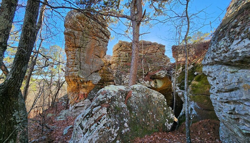
In between float season and waterfall hiking season lies a season of dubious anticipation for many outdoor enthusiasts. When there’s not enough water to go floating, and waterfall hikes are non-existent. I call it the dry season. It’s one of the times of the year I often opt for mountain biking, even though I’m itching for a good hike. But there are some great non-waterfall day hikes out there to be had, like the one at Stem Rock Natural Area. Stem Rock is a cluster of rock formations, crevices, and small caves in Searcy County, AR, near the community of Oxley. If you enjoy hikes with cool rock formations, like Alum Cove or Kings Bluff, then you should enjoy this one. Although it’s not as big or impressive as those two, the short easy hike makes it definitely worth ...

Exploring Bluffton Preserve – A Natural Gem in the Southern Ozarks
Tucked away in a beautiful valley just six miles north of Clinton in the southern Ozarks lies the Bluffton Preserve Nature Area. This is another natural area managed by the Nature Conservancy. Through the help of generous donors, the Nature Conservancy is the same group responsible for bringing us other wonderful recreational areas like Rattlesnake Ridge and Blue Mountain. While exploring Bluffton Preserve, I immediately realized this place is an outdoors treasure chest. There are professionally built trails for mountain biking, hiking, and backpack camping. Four miles of the Archey Fork Little Red River flows right through the area, with an access point for launching canoes and kayaks. This picturesque stream provides swimming holes, fishing, and a beautiful backdrop for hiking and observ...

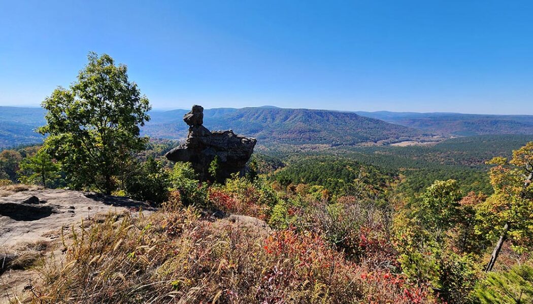
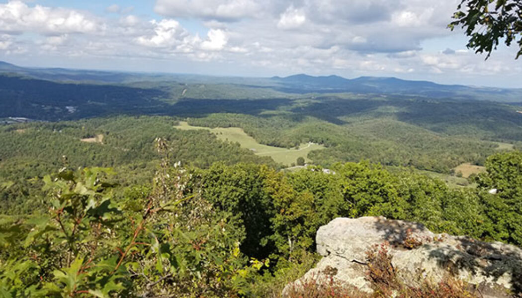
The Arkansas Sphinx: A Natural Wonder in the Ozarks
Nestled in the heart of the Ozark Mountains, lies a natural wonder known locally as the Arkansas Sphinx. This sandstone monolith rises 20 feet above its perch near the top of Hess Knob. Its profile bears a resemblance to the iconic sphinx of ancient Egypt. Measuring approximately 20-30 feet tall and just as wide, the Arkansas Sphinx is believed to have been formed over millions of years through erosion. Wind, water, and ice carved away at the softer rock layers, leaving behind the Sphinx-like profile in the sandstone that we see today. Standing tall and proud, the Arkansas Sphinx offers stunning panoramic views of the surrounding countryside. This popular destination for hikers, photographers, and nature enthusiasts stands as a testament to the power of nature’s artistry. This natura...

Steel Creek Overlook Hike on the Buffalo River Trail
The Steel Creek Overlook hike is a popular hiking spot along the Buffalo River Trail near Ponca, AR. The Western Section of the Buffalo River Trail (BRT) winds its way along the Upper Buffalo River for 37 miles from Boxley to Pruitt. It offers stunning views of the river, as well as access to a variety of other natural attractions, including waterfalls, caves, and bluffs. Along the way are six different trail heads to access different sections of the BRT. Steel Creek to Kyles Landing is one of these sections. It’s an 8.2-mile hike from Steel Creek to Kyle’s Landing. For many people this might be a bit much, especially for a day hike. But the Steel Creek Overlook hike only involves the first 1.5 miles of this section, and is not that difficult. The rewarding views are definitely...

Hiking and Mountain Biking at Blue Mountain Natural Area
To the west of Little Rock lies the Maumelle Pinnacles chain of mountain peaks. These peaks somewhat mark the eastern gateway to the Ouachita Mountains. The Maumelle Pinnacles consist of three peaks: Pinnacle Mountain, Rattlesnake Ridge, and Blue Mountain. Pinnacle Mountain has been one of Arkansas’ most visited state parks for decades. And since opening in 2018, Rattlesnake Ridge has become a popular outdoors spot for folks seeking to avoid the Pinnacle crowds. Both of those locations offer excellent hiking and mountain bike trails. And in June of 2023, the third and final peak in the chain was opened to the public. Thanks to the Nature Conservancy and Arkansas Natural Heritage Commission, we now have hiking and mountain biking at Blue Mountain Natural Area. Directions On Hwy 10 wes...

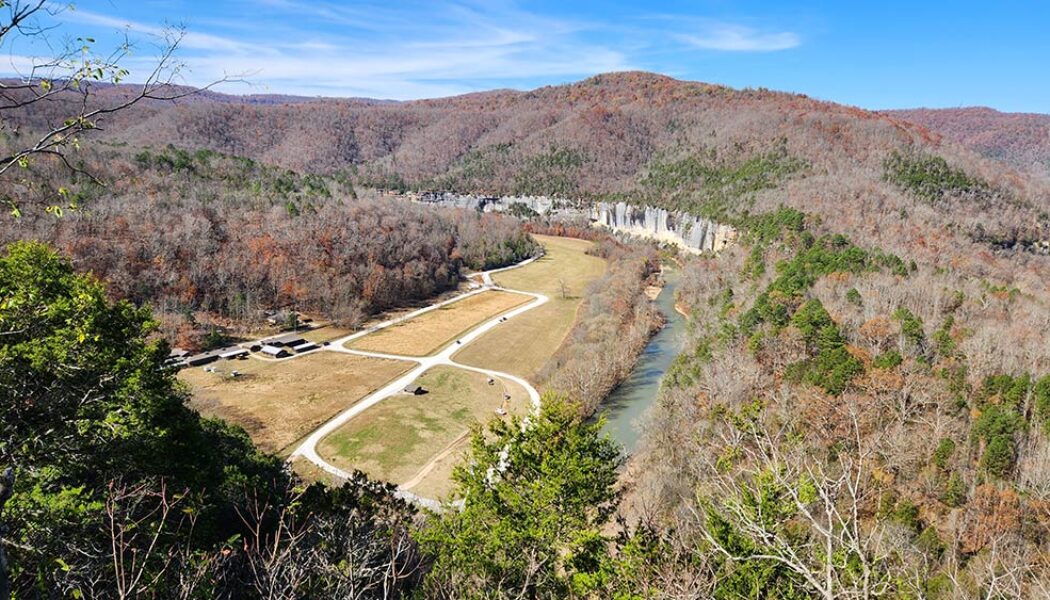
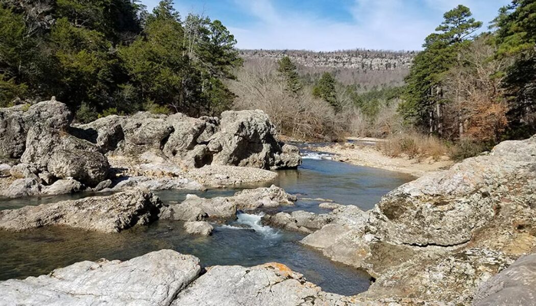
Harris Creek Trail Hike at the Cossatot River
I spent most of my adult life thinking the Cossatot River was so far away from my home in Central Arkansas. I also spent most of that time thinking that Cossatot River State Park was only a destination for whitewater paddlers. It turns out that neither of those things are true, as I found out in 2021. In my first visit to the park, I went to Cossatot Falls to watch the kayakers take on the Class IV whitewater. And while I didn’t see any paddlers hit the “Skull Crusher” that day, I did find a pretty great hiking area. I didn’t give myself enough time that day to explore all the trails there. But I saw enough to know I had to make a return trip to do the Harris Creek Trail hike. The Harris Creek Trail at Cossatot River State Park is one of the four main hiking trails ...

Hike to Buzzards Roost
I find something to enjoy about every hike that I do. But some hikes are better than others. And then there are the ones that really stand out from the rest. Those are usually the ones where I spend the whole time thinking “how am I just now visiting this place?!”. The hike to Buzzards Roost is the latest one that really blew me away. Maybe it’s because I geek out a little bit over crazy rock formations (see video below), and this hike is full of them. This geological wonderland has two natural bridges and a huge rock outcropping/vista full of caves and tunnels. I would compare it to the Bear Cave Trail area at Petit Jean State Park, but more impressive. It also didn’t hurt that we caught this area on the last weekend of peak leaf season this fall. This hike has a c...

Round Top Mountain Hiking Trails
There are many hikes in Arkansas that are better at certain times than others. And when you can’t do those, you need a backup plan. I have a list of hikes that I have been saving for times when rivers and waterfalls are dry. These are my “Plan B” hikes. Not because they are not good hikes, but because they can be done at any time. Hikes like Centerpoint/Goat Trail to Big Bluff or the Mt. Nebo Rim Trail for example. The latest Plan B hike I’ve checked off my list was a visit to Round Top Mountain hiking trails. I have passed by Round Top Mountain dozens of times on my way to Jasper or the Upper Buffalo River area. This Fall I finally had a good chance to stop in and hike it. I had been out waterfall hunting up Hwy 7 right after a rain. And after striking out on...
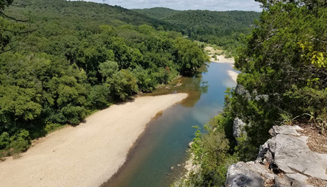

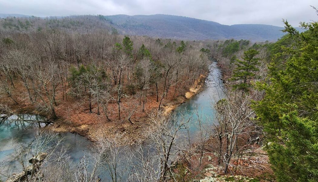
Hiking the Riverview Trail at Tyler Bend
It seems like every Arkansas Summer has a stretch of drought sometime between July and September. When the float rivers dry up and waterfall hikes become… well, just hikes. This summer (2021) has been especially dry and hot, making it difficult to get out and do these things. So what can you do when you just gotta get out there? How about a vista hike? Well that’s exactly what I did one Sunday in August. I hiked the Riverview Trail at Tyler Bend Recreation Area on the Buffalo River. There are a lot of high bluffs along the Buffalo River with trails leading to some great views. I like to hit those trails this time of year. Last Summer I did the most popular, Centerpoint/Goat Trail to Big Bluff near Compton. So this time I chose something closer to the Lower Buffalo. There a...

Hike to Winding Stairs on Eagle Rock Loop
I continue to be blown away by the natural beauty in our state. Just when I think I’ve seen the prettiest hike in Arkansas, I eventually go on another one that changes my mind. The hike to Winding Stairs on the Eagle Rock Loop Trail in the Ouachitas is the latest one. I’ll admit that I have not given enough attention to the Ouachita Mountain region so far. Sometimes I get in the habit of heading straight to the Ozarks for hiking waterfalls and paddling rivers. But there are areas of the Ouachitas that are just as great and in my opinion, very underrated. This area around the Eagle Rock Loop is right up there with some of the best spots in the Ozarks. Many people have gotten confused and lost trying to follow this trail. Unless you download a map, it can be easy to get off the t...
- 1
- 2
