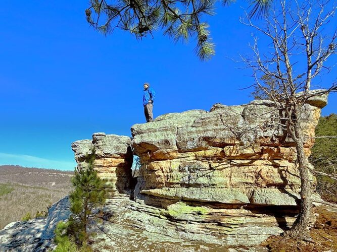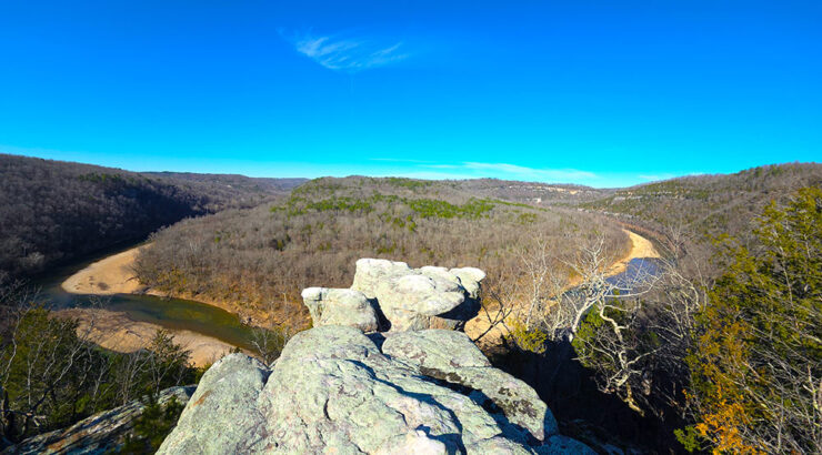
Hiking to Devil’s Tea Table is one of those Buffalo River experiences that quietly surprises you. The hike to Devil’s Tea Table leads to a massive rock formation perched above the Buffalo River in the Leatherwood Wilderness area of the Ozarks near the small community of Cozahome, Arkansas. From the edge, you get a wide, sweeping view of the river corridor below. Additionally, this area sits within a landscape packed with hiking opportunities along the Buffalo River and throughout the Leatherwood Wilderness.
Sometimes we hike to waterfalls. But when there’s no rain, we find alternatives. During the dry season, we usually aim for views, caves, or unique rock features instead. The hike to Devil’s Tea Table delivers a huge rock formation sitting right on top of a scenic vista. As a result, you get a 2-for-1 kind of hike that feels especially rewarding.
Quick Glance
Distance: Approximately 4.5 mile out and back
Difficulty: Easy
Parking Coordinates: 36.097587, -92.522776
View towards Ludlow Bluff : 36.09408, -92.53050
Scenic View of Buffalo River : 36.09323, -92.54118
Devil’s Tea Table : 36.082524, -92.539652
(Copy/Paste Coordinates into GPS or Google Maps search bar)
Directions
From the intersection at Hwy 27 and Hwy 14 at Harriet, travel north on Hwy 14 for 3.4 miles. Turn right on Cozahome Rd. Stay on Cozahome Rd for 8.2 miles, through the sharp left turn at the Turkey Pen Springs intersection. Continue on Cozahome Rd until it dead-ends. That is the parking area.
What to Expect
The Hike
The hike to Devil’s Tea Table is a 4.5-mile out and back hike that feels approachable for most hikers. Overall, the route is relatively easy and mostly flat. There are only a couple of spots with short, gradual elevation changes, and they are very minor. Because of this, the hike never feels strenuous.
From the parking area, you will immediately notice two trails. The trail to the right heads toward Ludlow Bluff. Instead, take the trail to the left to begin the hike to Devil’s Tea Table. This route feels more like a volunteer trail than a maintained one. Even though there is a post that looks like an official trailhead, the trail is not well defined. In the woods, the path is completely covered with leaves and nearly disappears. As a result, you end up watching for faint footprints and trusting your instincts.
Directions to Devil’s Tea Table are difficult to capture in writing. Because of that, we recommend checking out our video further below. Basically, you will head straight out from the parking area, traveling west through the woods along the ridge. At times, there is a faint trail. Other times, it feels like a leaf-covered road. And occasionally, it becomes a full bushwhack where foot traffic is your only guide. Still, if you stay in that general direction, things eventually improve. You will hit a more distinct trail closer to the bluffs overlooking the Buffalo River Valley. For this reason, downloading the GPX track from AllTrails and using a GPS app is highly recommended.
Private Property
The route to Devil’s Tea Table follows the boundary of National Park Service land and comes very close to private property. You should actively watch for private property markers along the way. The private property boundary is visible on the AllTrails app – another reason to keep that handy. Always respect property owners and avoid entering private land without permission.


Scenic Views
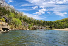
Along the way, there are a few nice vista views before reaching the Tea Table. See the coordinates for those listed in the Quick Glance section. Once you reach the trail along the bluffs, navigation becomes much easier. Stay on that trail as it approaches an open area. Suddenly, Devil’s Tea Table appears, and you will know without a doubt that you have arrived. In my opinion, the panoramic view from Devil’s Tea Table ranks among the best along the Buffalo River. While nothing beats the view from Big Bluff for me, this one still ranks very high.
Buffalo River Trail/Ozark Highlands Trail Confusion
This route is easily confused with the Buffalo River Trail(BRT), but it is not officially part of the BRT. We originally thought it was connected, but further research showed the BRT ends at Highway 14 at Dillard’s Ferry. However, the Ozark Highlands Trail(OHT) joins the BRT at Woolum and continues east and then north after Dillard’s Ferry. Unfortunately, there are gaps in the OHT, and the section near Devil’s Tea Table is one of them. Because of this, the route is mostly a bushwhack with scattered sections of recognizable trail. Even though many OHT thru-hikers use this route, it remains an official gap, so GPS navigation is very necessary. You can learn more about that here and also here.
Plan Your Trip
Hiking Time: Approx 2-3 hrs
4WD Needed?: No
Cell Service: Little to none, except at the Tea Table (AT&T)
Map or GPS needed: GPS track highly recommended
Because the trail is poorly marked, leaf-covered, and sometimes non-existent, downloading a GPX track is essential. Additionally, the route tends to become overgrown during the summer months. For that reason, late fall through early spring is the best time to hike. The hike to Devil’s Tea Table took us about three hours, although we spent plenty of time relaxing at the overlook. If you plan to add Ludlow Bluff, starting around 9 or 10 AM is a smart move.
Cell service is spotty throughout the Lower Buffalo River area. However, there is surprisingly a fairly strong signal at Devil’s Tea Table itself. There are no restrooms anywhere nearby, so plan accordingly. The closest places to buy snacks and drinks are in the surrounding small communities before reaching the trailhead. As always, practice Leave No Trace principles while hiking here. Long-term visitors will also find countless hiking opportunities along the Buffalo River and throughout the Leatherwood Wilderness Area. Many of the waterfall hikes can be found on the Waterfalls in Arkansas Map. While there is no camping directly at the trail, several campgrounds sit nearby along the Buffalo River, and cabins are available to rent. The closest restaurants are in Marshall, which is over 30 minutes away.